Severe Storms and Flash Flood Risk Put 15 New Jersey Counties Under Weather Alert Monday

Residents across several parts of New Jersey are being urged to stay alert Monday as forecasters warn of potentially dangerous thunderstorms capable of producing heavy rainfall, damaging winds, and localized flash flooding. Weather officials have placed portions of 15 counties under a flood watch beginning this afternoon as a developing storm system moves across the region.
The flood watch is scheduled to take effect at 2 p.m. and includes Bergen, northwestern Burlington, Camden, Essex, Gloucester, Hudson, Hunterdon, Mercer, western Monmouth, Middlesex, Morris, Passaic, Salem, Somerset, and Union counties. Forecasters say conditions are favorable for periods of intense rainfall that could quickly overwhelm drainage systems and create hazardous travel conditions.
According to weather officials, widespread rainfall totals between 1 and 2 inches are expected in the affected areas. However, isolated locations could receive as much as 3 inches of rain if stronger storms repeatedly move over the same communities. The greatest concern is the possibility of very heavy downpours developing in a short period of time, with rainfall rates reaching up to 2 inches per hour during the strongest storms.
While many areas started the day with calm and relatively quiet weather conditions, meteorologists caution that the situation is expected to change significantly during the afternoon and evening hours. Scattered thunderstorms are forecast to develop during the middle of the afternoon before becoming more organized later in the day. As storms strengthen, the threat of flash flooding is expected to increase across vulnerable locations.
In addition to flooding concerns, severe weather is also expected to accompany some of the storms. Damaging wind gusts are considered the primary hazard, but forecasters have not ruled out the possibility of an isolated tornado. The evolving weather pattern is being closely monitored as a low-pressure system moves through the region, creating conditions supportive of stronger thunderstorm development.
Most of New Jersey remains under a Level 2 out of 5 severe weather risk, indicating the potential for scattered severe thunderstorms capable of producing localized damage. Weather experts say storms may initially form as isolated cells before organizing into clusters during the late afternoon and evening, increasing the likelihood of stronger wind impacts and heavier rainfall.
Temperatures across the state are expected to climb into the upper 70s and middle 80s on Monday before storms arrive. Along the Jersey Shore, beachgoers are also being advised to exercise caution due to dangerous ocean conditions. A high risk of rip currents is in place for Ocean, Atlantic, and Cape May counties, while Monmouth County faces a moderate rip current risk.
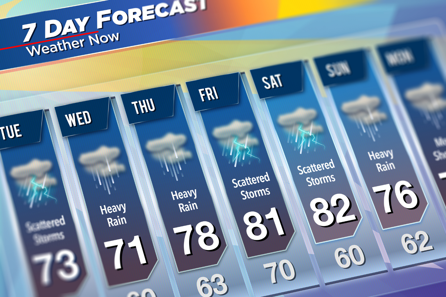
The threat of heavy rain and severe weather is expected to gradually decrease overnight as the storm system moves away from the area. However, unsettled weather may not be completely finished. A cold front moving through the region on Tuesday could trigger additional scattered showers and thunderstorms during the afternoon. Current forecasts indicate these storms are not expected to reach severe levels.
Temperatures on Tuesday are forecast to remain comfortable, with highs generally ranging from the upper 70s to the lower 80s across much of the state. Conditions are expected to improve further during the middle of the week, with Wednesday and Thursday forecast to bring drier weather, clearing skies, and seasonable temperatures.
Looking ahead to the end of the week, another cold front may approach the region between Friday and Saturday. This system could bring another round of showers and thunderstorms, although forecasters note there remains considerable uncertainty regarding its exact timing. Current forecast models continue to show differences in when the system could arrive, making it too early to determine specific impacts.
For now, weather officials are encouraging residents in the flood watch area to monitor forecasts throughout the day, remain aware of changing conditions, and be prepared for rapidly developing thunderstorms during the afternoon and evening hours. Motorists should use extra caution during periods of heavy rainfall, especially in locations prone to flooding or poor drainage.
Sources
National Weather Service (Official Government Weather Agency)