


New Jersey Heat Wave Continues as Evening Storm Chances Raise Flooding and Wind Concerns
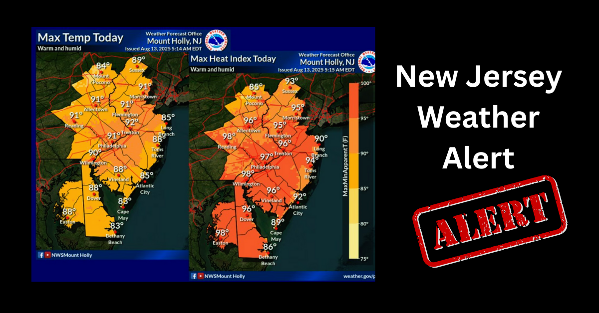
New Jersey residents should prepare for another day of dangerous heat and heavy humidity as forecasters warn that isolated thunderstorms could develop later this evening. While not every community is expected to see rain, any storm that forms may bring intense downpours, gusty winds, and localised flooding, especially in areas that have already received significant rainfall over the past few days.
The combination of high temperatures and tropical-level humidity continues to create uncomfortable and potentially hazardous conditions across much of the state. Weather officials are urging residents to take precautions as heat advisories remain in effect across many parts of New Jersey through Friday and, in some locations, into Saturday.
Although air temperatures are expected to remain in the upper 80s and lower 90s, the high moisture levels in the atmosphere will make it feel much hotter. Heat index values are forecast to range from the mid-90s to as high as 104 degrees in portions of northern, central, and southern New Jersey. These conditions increase the risk of heat-related illnesses, particularly for older adults, young children, outdoor workers, and people with underlying health conditions.
Forecasters say isolated showers and thunderstorms may begin developing during the late afternoon and continue into the evening. The highest chances for storms are expected across areas northwest of the Interstate 95 corridor, although a few storms could expand farther southeast depending on how weather conditions develop.
Even though widespread severe weather is not expected on Thursday, meteorologists caution that any thunderstorm has the potential to become dangerous because of the amount of moisture in the atmosphere. Heavy rainfall over a short period could quickly overwhelm drainage systems and cause localised flash flooding in low-lying neighbourhoods, roadways, and other flood-prone locations.
The flood risk is especially concerning because many communities are still recovering from recent rounds of heavy rain. Some parts of New Jersey recorded more than three inches of rainfall during storms earlier this week, leaving the ground saturated and reducing its ability to absorb additional water. As a result, even isolated storms could create flooding problems in areas that have already experienced repeated rainfall.
Strong wind gusts are another concern. Thunderstorms that develop later today could produce localised damaging winds capable of bringing down tree limbs, causing scattered power outages, and making travel difficult. Drivers are encouraged to slow down during heavy rain and avoid driving through flooded roadways, where water depth may be difficult to judge.
The unsettled weather pattern is expected to continue into Friday, when forecasters believe thunderstorm coverage will become more widespread. Weather experts say Friday’s storms could be better organised than today’s activity, increasing the possibility of stronger wind gusts and additional heavy rainfall across larger portions of the state.
At the same time, the oppressive heat will remain firmly in place. Heat advisories continue for much of New Jersey as dangerous humidity prevents temperatures from cooling significantly overnight. Overnight lows are expected to stay in the 70s, offering little relief before another hot afternoon arrives.
Communities along the Interstate 95 corridor, as well as several central and southern New Jersey counties, are expected to experience some of the highest heat index values through the end of the week. In northern New Jersey, similar conditions are forecast through Friday evening before gradual improvements begin later in the weekend.
Residents planning to spend time outdoors are encouraged to stay hydrated, wear lightweight clothing, limit strenuous activities during the hottest part of the day, and check on family members and neighbours who may be more vulnerable to extreme heat. Pet owners should also ensure animals have access to shade and fresh water, as pavement temperatures can become dangerously hot during prolonged heat waves.
Beachgoers should also use caution. Along portions of the Jersey Shore, weather officials continue to warn of a moderate risk of dangerous rip currents. Increasing southerly winds and surf conditions may create hazardous swimming conditions through Friday, even when skies appear clear.
Looking ahead, weather conditions may begin to improve late Saturday as a weak cold front approaches the region. While additional showers and thunderstorms remain possible, the front is expected to bring slightly less humid air by Sunday. Forecast models suggest Sunday could become the driest day of the extended forecast, although temperatures will still remain seasonably warm.
The break from extreme humidity may be brief. Forecasters expect moisture to return early next week, allowing hot and humid conditions to rebuild across New Jersey. Daily chances for afternoon and evening thunderstorms are also expected to continue into the start of the new week.
With heat, humidity, and changing weather patterns combining across the region, residents are encouraged to monitor updated forecasts and remain alert for any watches or warnings that may be issued as conditions evolve.
Sources
- National Weather Service (NWS)
- National Oceanic and Atmospheric Administration (NOAA)
- NOAA Storm Prediction Center
- National Weather Service Mount Holly Weather Forecast Office
- National Weather Service New York Weather Forecast Office

