New Jersey Faces Storm Risks Before Intense Heat Wave Peaks Through Friday

New Jersey residents are preparing for a challenging stretch of weather as thunderstorms, rising humidity, and dangerous heat are expected to impact the state through the end of the workweek. Forecasters are warning that conditions could become increasingly uncomfortable and potentially hazardous as temperatures climb and storm chances continue over the next several days.
Wednesday is expected to bring mostly cloudy skies with temperatures remaining in the mid-80s across much of the state. While a few isolated showers may develop during the morning hours, weather conditions are expected to become more active later in the day. Scattered thunderstorms are forecast to form during the afternoon and evening, creating the possibility of damaging wind gusts and brief periods of heavy rainfall.
Meteorologists say the storms are not expected to organize into a widespread severe weather event. However, some individual thunderstorms could become strong enough to produce localized impacts, especially during the late afternoon and evening commute period. Residents are encouraged to stay alert for changing weather conditions if they have outdoor plans.
The humid air mass moving into the region will remain in place overnight, leading to warm and muggy conditions across New Jersey. Overnight temperatures are expected to stay unusually mild, ranging from the mid-60s to lower 70s. Areas that receive rainfall during the day could also see patches of fog or low clouds develop overnight.
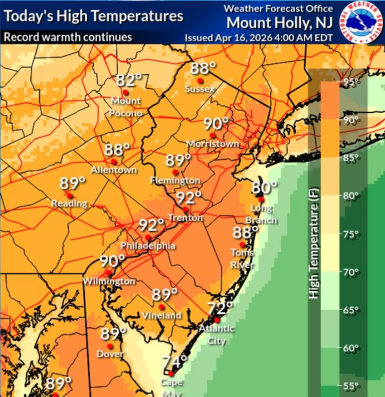
Weather concerns are expected to increase significantly on Thursday as temperatures surge into the low and middle 90s across much of the state. Combined with high humidity levels, the heat index could reach or exceed 100 degrees in some locations, creating potentially dangerous conditions for anyone spending extended time outdoors.
Because of the expected heat and humidity, a heat advisory has been issued for most of New Jersey beginning Thursday morning. Health officials generally advise residents to limit strenuous outdoor activity during the hottest part of the day, remain hydrated, and check on vulnerable individuals such as older adults and those without access to air conditioning.
In addition to the extreme heat, another round of thunderstorms may develop Thursday. Forecasters indicate that severe weather remains possible, with damaging winds representing the primary threat. Atmospheric conditions could also support a brief tornado if thunderstorms strengthen during the day. While the tornado risk remains relatively low, it extends across the state wherever storms develop.
The weather pattern is expected to continue into Friday, with temperatures potentially climbing even higher than those experienced on Thursday. The combination of intense heat and elevated humidity will likely make conditions feel oppressive across many communities.
A cold front approaching the region on Friday could trigger additional showers and thunderstorms. Some of these storms may become severe before the front moves through. Forecasters say the arrival of the front should finally bring an end to the dangerous heat and humidity that have dominated the week’s forecast.
Looking ahead to the weekend, weather conditions are expected to improve noticeably. Saturday and Sunday should remain mainly dry, with temperatures still warm in the upper 80s to lower 90s. The key difference will be lower humidity levels, allowing for much more comfortable conditions compared with the latter part of the workweek.
Another weather system may approach late in the weekend or early next week, bringing the possibility of additional showers and thunderstorms. For now, however, the immediate focus remains on the combination of storm threats and potentially dangerous heat expected across New Jersey through Friday.
Residents are encouraged to monitor local forecasts throughout the week as weather conditions can change quickly, particularly when severe thunderstorms and extreme heat occur together. Staying informed and taking appropriate precautions can help reduce risks during this active weather period.