


N.J. weather: Fierce thunderstorms could unleash flash floods, damaging winds, tornadoes today. Latest on timing.
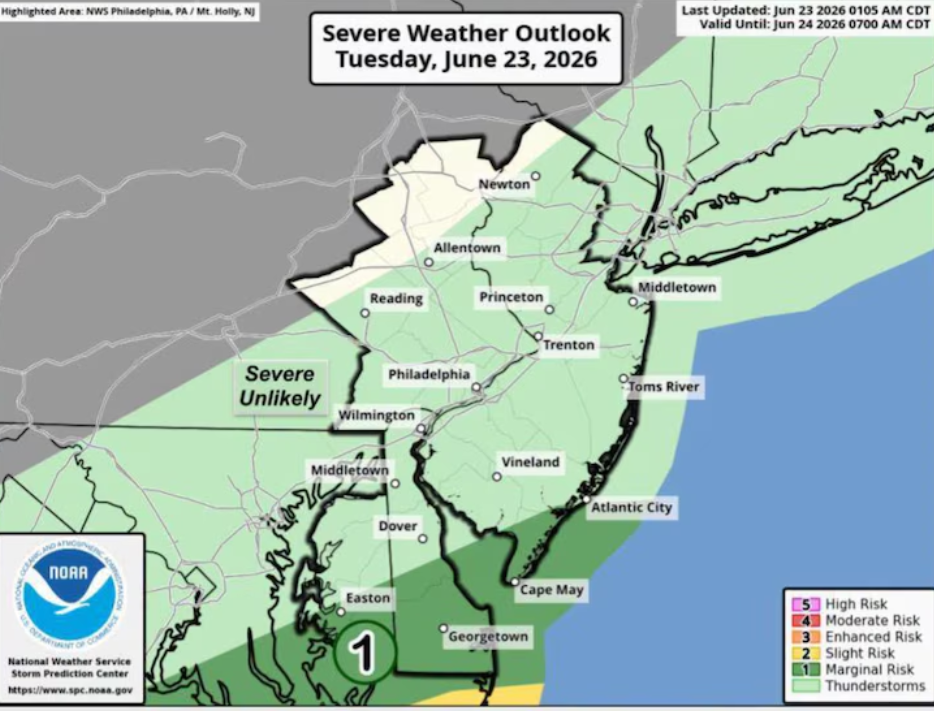
New Jersey Faces High Risk of Severe Storms Tuesday as Flash Flooding, Damaging Winds and Isolated Tornadoes Threaten State
New Jersey is preparing for a dangerous round of severe weather on Tuesday as powerful thunderstorms are expected to move across the state, bringing the risk of flash flooding, damaging wind gusts, large hail, and a few possible tornadoes.
Weather conditions are expected to become more active throughout the day, with the strongest storms forecast to develop during the afternoon and continue into the evening. Forecasters say residents should closely monitor weather updates and be prepared for rapidly changing conditions as the storms move through different parts of the state.
A flood watch remains in effect for 14 New Jersey counties through early Wednesday due to the potential for heavy rainfall and flooding. Areas included in the flood watch are Bergen, Camden, Essex, Gloucester, Hudson, Hunterdon, Mercer, Middlesex, Monmouth, Morris, Passaic, Somerset, Union, and northwestern Burlington counties.
Meteorologists expect showers and thunderstorms to increase as the day progresses, with the greatest chance of severe weather occurring between approximately 2 p.m. and 9 p.m. During this period, some thunderstorms could become severe enough to produce destructive wind gusts, isolated tornadoes, and large hail.
Heavy rainfall is another major concern. The strongest thunderstorms could produce rainfall rates of up to 3 inches per hour, making it difficult for drainage systems to keep up. Across much of the state, total rainfall amounts between 2 and 4 inches are expected, increasing the likelihood of flash flooding in low-lying areas, roads, and locations that typically experience poor drainage.
The latest forecast comes only days after parts of New Jersey experienced significant rainfall during weekend storms, leaving some locations more vulnerable to additional flooding if heavy rain develops again.
Frequent cloud-to-ground lightning is also expected with stronger thunderstorms, creating another safety concern for anyone spending time outdoors. Residents are encouraged to seek shelter immediately if thunderstorms approach their area.
Most of New Jersey has been placed under an enhanced risk, classified as Level 3 out of 5, for severe weather on Tuesday. Only the northeastern section of the state near New York City remains under a slight risk classification, indicating a somewhat lower but still notable chance of severe storms.
Despite the storm threat, temperatures are expected to climb into the 80s across much of the state, while humidity levels continue to increase, creating conditions favorable for strong thunderstorm development.
The unsettled weather pattern is expected to continue into Wednesday as a cold front moves across New Jersey. Additional showers and thunderstorms are forecast, mainly affecting central and southern parts of the state.
On Wednesday, the primary severe weather concern is expected to shift toward locally damaging wind gusts. However, heavy rainfall may still produce localized flash flooding in some communities. Central and southern counties remain under a slight risk, or Level 2 out of 5, for severe thunderstorms during the day.
Beachgoers should also remain cautious, as a high risk of dangerous rip currents is expected along Jersey Shore beaches on both Tuesday and Wednesday.
Weather conditions are forecast to improve by Thursday after the cold front moves away from the region. Sunny skies and more comfortable temperatures in the upper 70s to mid-80s are expected to return, providing a break from the active weather pattern.
Looking ahead, the upcoming weekend is expected to bring continued dry weather with abundant sunshine and seasonable temperatures through Sunday, offering much calmer conditions across New Jersey after the midweek storms.
Sources
- National Weather Service (NWS)
- National Weather Service Mount Holly Weather Forecast Office
- National Oceanic and Atmospheric Administration (NOAA)

