New Jersey Faces Life-Threatening Heat as Temperatures Could Climb Above 100 Degrees Through Holiday Weekend
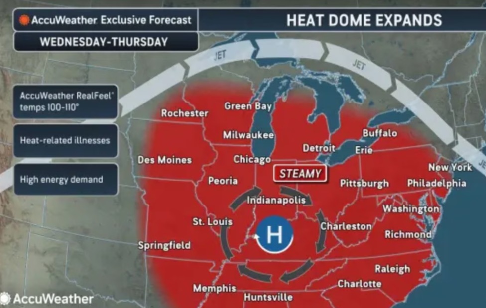
New Jersey is preparing for a dangerous stretch of extreme heat that is expected to begin on Wednesday and continue through the Fourth of July holiday on Saturday. Weather officials are warning that the upcoming heat wave could bring some of the hottest temperatures ever recorded in parts of the state, with several days potentially reaching or exceeding 100 degrees.
According to the latest forecast from the National Weather Service, the hottest conditions are expected on Thursday and Friday. Afternoon temperatures could rise between 100 and 105 degrees, while high humidity will make it feel even hotter. Heat index values may reach between 105 and 110 degrees, creating dangerous conditions for anyone spending time outdoors.
Forecasters say this heat wave has the potential to challenge long-standing temperature records across New Jersey. The state’s highest recorded temperatures at its three major airport weather stations include 108 degrees at Newark Airport in 2011, 106 degrees at Trenton Airport in both 1936 and 2011, and 106 degrees at Atlantic City Airport in 1969. If current forecasts hold, some of these historic records could be tested later this week.
Because of the expected severity of the heat, the National Weather Service has issued an Extreme Heat Watch covering all of New Jersey from Wednesday afternoon through Saturday evening. Residents are encouraged to stay informed as conditions develop throughout the week.
The weather early in the week will serve as a buildup to the much hotter conditions ahead. Monday is expected to remain warm, with sunny skies and afternoon temperatures in the mid to upper 80s. Overnight temperatures will fall into the 60s, offering some relief before the hotter air arrives.
On Tuesday, temperatures will climb closer to 90 degrees in many areas. Northern parts of the state could also experience a few afternoon and evening thunderstorms. Forecasters say damaging wind gusts would be the primary concern if storms develop.
The most significant change will arrive on Wednesday as temperatures rise into the mid to upper 90s. Combined with increasing humidity, it will feel closer to 100 to 105 degrees in many locations. These conditions mark the beginning of what is expected to be the most dangerous period of the week.
Thursday and Friday are forecast to be the peak of the heat wave. Actual air temperatures are expected to reach between 100 and 105 degrees across parts of the state. The added humidity will make conditions even more uncomfortable, with feels-like temperatures ranging from 105 to 110 degrees during the hottest part of the day.
The heat is also expected to continue overnight. Instead of cooling down significantly after sunset, nighttime temperatures may stay in the upper 70s to lower 80s. These warmer nights can make it harder for homes without air conditioning to cool down and reduce the body’s ability to recover from daytime heat.
As the Fourth of July weekend begins, temperatures may ease slightly on Saturday but will remain dangerously high. Highs are expected to reach the mid-90s to near 100 degrees, while humidity will continue to make it feel between 100 and 110 degrees.
There is also a chance for afternoon and evening thunderstorms beginning Friday, with better opportunities for showers and storms on Saturday and Sunday. These weather changes could affect outdoor holiday activities in some areas, although the heat is still expected to remain a major concern.
Looking ahead, temperatures are forecast to stay above normal even after the holiday weekend. Highs on Sunday and into early next week are expected to remain in the low to mid-90s, keeping much of New Jersey under continued hot and humid conditions.
Residents across the state should closely monitor the latest weather updates throughout the week as New Jersey prepares for what could become one of its most significant heat events in recent years.
Sources
National Weather Service (Official)