


New Jersey Braces for Intense Heat as Heat Index Could Climb Above 100 Degrees on Wednesday
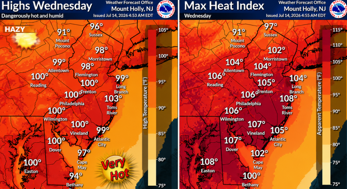
New Jersey is preparing for a dangerous stretch of summer weather as extreme heat and rising humidity are expected to push feels-like temperatures well above 100 degrees on Wednesday. Forecasters are urging residents to take precautions as the hottest day of the week approaches, with parts of the state facing the highest level of heat alerts.
According to the National Weather Service, temperatures will continue to climb through Tuesday before reaching their peak on Wednesday. Afternoon highs are expected to range from the upper 90s to around 100 degrees across much of New Jersey. Combined with increasing humidity, heat index values could reach between 100 and 109 degrees in many locations, creating conditions that may be dangerous for anyone spending extended time outdoors.
Because of the expected extreme heat, the National Weather Service has issued Extreme Heat Warnings for eight New Jersey counties from 10 a.m. until 8 p.m. Wednesday. The warning covers Burlington, Camden, Gloucester, Mercer, Middlesex, Monmouth, Ocean and Somerset counties. The remaining counties across the state are under Heat Advisories as dangerously hot conditions are also expected there.
Tuesday will also be hot, with sunny skies allowing temperatures to climb into the upper 80s and middle 90s. Humidity levels are expected to make it feel only slightly warmer than the actual air temperature during the day. However, weather conditions are forecast to become much more uncomfortable by Wednesday as moisture in the air increases significantly.
Wednesday’s heat could approach or even challenge long-standing temperature records in parts of the state. Existing records for July 15 include 101 degrees at Trenton Airport, 100 degrees at Atlantic City Airport and 104 degrees at Newark Airport, all established in 1995. Whether those records are broken will depend on the final afternoon temperatures.
Even coastal communities are expected to experience unusually hot conditions. Areas along the Jersey Shore, which often receive some relief from ocean breezes, are forecast to see afternoon temperatures in the middle to upper 90s. Winds blowing from the west are expected to limit cooling from the ocean, allowing heat index values to rise between 100 and 105 degrees in many shoreline communities.
Beach visitors should also be aware of hazardous ocean conditions. A high risk of dangerous rip currents is expected along Jersey Shore beaches through Wednesday, especially from late Tuesday afternoon into Wednesday morning. Officials encourage swimmers to remain alert and follow local beach safety guidance.
A cold front is expected to move across the region late Wednesday, bringing a gradual change in weather. While it is not expected to provide immediate relief during the day, it could trigger isolated thunderstorms during the late afternoon and evening, mainly across northern New Jersey.
Forecasters are also monitoring the possibility of smoky conditions as wildfire smoke from Canada moves into the region. If smoke reaches the area, it could affect visibility and air quality in some locations.
Although temperatures will ease somewhat after the cold front passes, Thursday is still expected to remain hot. Heat index values may continue reaching the upper 90s to low 100s, particularly along and southeast of the Interstate 95 corridor.
Conditions are expected to become less humid by Friday, providing some improvement despite afternoon temperatures that could still reach the low to middle 90s in parts of the state.
Looking ahead to the weekend, weather conditions are expected to become more unsettled. Daily chances for showers and thunderstorms are in the forecast as another cold front approaches New Jersey. Some storms on Saturday could become severe and produce heavy rainfall, increasing the potential for flash flooding in some areas.
Meteorologists say there is still uncertainty regarding how quickly the approaching front will move through the region. That timing will determine whether weather conditions improve by late Sunday or whether showers and thunderstorms continue into early next week.
Residents are encouraged to stay informed as the forecast develops and to monitor official weather updates while dangerous heat remains in place across New Jersey.
Sources
- National Weather Service (NWS)
- National Weather Service Mount Holly Forecast Office
- National Weather Service Weather Prediction Center (WPC)

