
New Jersey Sees Widespread Rain and Spotty Thunderstorms as Weather System Moves Through State
New Jersey is experiencing a wet and unsettled weather pattern today as a moving storm system brings periods of rain and isolated thunderstorms across much of the state. While most areas are seeing steady showers, parts of southern New Jersey face a slightly higher chance of stronger storm activity during the day.
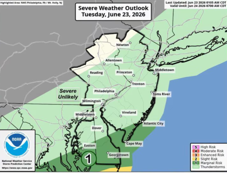
Forecasters note that isolated severe thunderstorms cannot be ruled out, especially in the southern counties. The Storm Prediction Center has placed Cape May County and parts of Atlantic County under a marginal risk, which is level 1 out of 5, indicating a low but noticeable threat for both severe weather and localized heavy rainfall. Other regions across New Jersey are expected to experience lighter rain with a much lower risk of severe conditions.
Rain is expected to continue through the afternoon hours before gradually weakening later in the evening as the system begins to move out of the region. Temperatures today are staying mild, mainly in the 70s, keeping conditions cool but humid due to the persistent cloud cover and moisture in the atmosphere.
The National Weather Service reports that more than 1,100 homes and businesses were still without power Tuesday morning following recent thunderstorms that brought strong winds and heavy rainfall across parts of the state. Cleanup and restoration efforts are ongoing in affected areas as crews work to restore electricity.
Conditions are expected to improve later tonight as the storm system fully exits New Jersey, allowing for calmer weather to return temporarily.
Looking ahead, Wednesday is expected to bring the most stable weather of the week. Skies will turn mostly sunny, and temperatures are forecast to rise into the 80s, offering a brief break from the wet conditions.
Thursday will start off pleasant as well, but weather conditions are expected to shift again later in the day. Showers and thunderstorms may develop during the late afternoon and evening hours. Winds could also increase slightly, with gusts reaching around 15 to 20 mph as the next weather system begins to approach.
By Friday, another round of widespread rain and thunderstorms is expected to move into the region. This unsettled pattern may continue into the weekend, with periodic showers possible on Saturday, especially during afternoon and evening hours. However, forecasters note some uncertainty in how quickly the system will move out, meaning timing and intensity of weekend rain may still change.
Residents across New Jersey are advised to stay updated on local forecasts as conditions remain changeable through the end of the week, with alternating periods of dry weather and incoming storm systems.
Sources:
National Weather Service
Storm Prediction Center