New Jersey Braces for Most Intense Heat Stretch Since 2011 as Extreme Heat Warning Takes Effect

New Jersey is preparing for a prolonged period of dangerous summer weather after the National Weather Service upgraded its heat alerts to an Extreme Heat Warning for most of the state. The warning will begin at noon on Wednesday and comes as forecasters expect several days of exceptionally high temperatures and dangerous humidity that could create life-threatening conditions.
According to the National Weather Service, this is not an ordinary summer heat event. Forecasters say the combination of extreme temperatures and long-lasting heat could make this the hottest weather New Jersey has experienced since July 2011. The extended duration of the heat is expected to increase risks for residents while also putting added pressure on infrastructure across the state.
The Extreme Heat Warning now covers 18 New Jersey counties. Meanwhile, Atlantic, Cape May, and Cumberland counties remain under an Extreme Heat Watch as weather officials continue to monitor conditions that could require additional alerts.
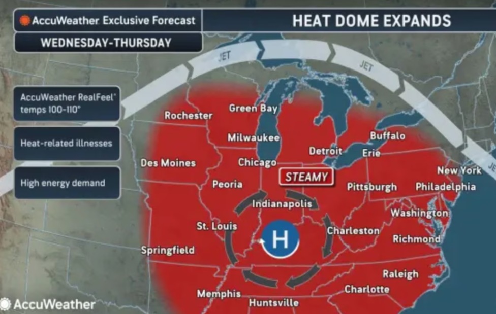
Beginning Wednesday, temperatures are expected to climb into the mid-90s and upper 90s across much of New Jersey. As humidity continues to increase, it could feel between 100 and 105 degrees in many locations. The hottest conditions are expected on Thursday and Friday, when actual temperatures may reach between 100 and 105 degrees in some areas. Combined with high humidity, heat index values could rise as high as 110 degrees.
Weather officials have warned that the intensity and length of this heat wave make it especially dangerous. Unlike shorter periods of hot weather, several consecutive days of extreme heat reduce opportunities for people, buildings, and infrastructure to cool down overnight. Nighttime temperatures are forecast to remain unusually warm, generally staying in the mid-70s to lower 80s from Wednesday night through Friday night, offering very little relief after sunset.
Tuesday will serve as the transition into the more dangerous weather pattern. Afternoon temperatures are expected to reach the upper 80s and lower 90s while humidity remains relatively lower compared to the days ahead. However, scattered thunderstorms could develop during the afternoon and evening, especially along and north of Interstate 78. The greatest chance for storms is expected after 2 p.m., with damaging wind gusts and frequent lightning identified as the primary hazards if storms develop.
As the week continues, isolated thunderstorms remain possible on Wednesday afternoon. By Friday, additional afternoon and evening thunderstorms could develop, and the chance for storms is expected to increase further during the Fourth of July holiday weekend. Forecasts indicate a 30% to 50% chance of thunderstorms on both Saturday and Sunday.
Although temperatures are expected to ease slightly over the weekend, conditions will remain extremely hot. High temperatures on Saturday are forecast to reach the mid-90s to near 100 degrees before gradually falling into the low to mid-90s by Sunday and Monday.
The expected heat could also challenge long-standing temperature records. New Jersey’s airport weather stations have recorded all-time highs of 108 degrees at Newark Airport in 2011, 106 degrees at Trenton Airport in both 1936 and 2011, and 106 degrees at Atlantic City Airport in 1969. Forecasters say record highs could be threatened on both Thursday and Friday if temperatures climb as expected.
Residents planning outdoor activities during the Fourth of July holiday period should be aware that both dangerous heat and the possibility of afternoon thunderstorms may affect celebrations and travel plans throughout the state.
Beachgoers should also pay close attention to surf conditions. A moderate risk of dangerous rip currents is in place Tuesday for beaches in Ocean, Atlantic, and Cape May counties. The National Weather Service expects that risk to increase to a high level on Wednesday, creating more hazardous conditions for anyone entering the water.
With multiple days of extreme temperatures expected, New Jersey is entering one of its most significant heat events in more than a decade. Weather officials continue to monitor the forecast closely and encourage residents to stay informed as conditions develop through the holiday weekend.
Sources
- National Weather Service (NWS)
- National Oceanic and Atmospheric Administration (NOAA)