New Jersey Faces Elevated Risk of Severe Storms and Flash Flooding Through Midweek
New Jersey residents should prepare for another round of unsettled weather as forecasters warn that strong thunderstorms, heavy rainfall, flash flooding, and damaging wind gusts could affect much of the state on Tuesday. While a few isolated storms may develop Monday afternoon, weather conditions are expected to become more active and hazardous as a stronger storm system moves across the region.
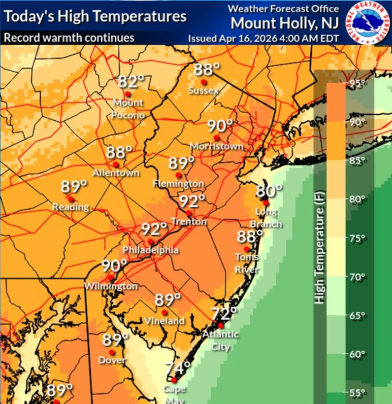
According to weather officials, scattered thunderstorms are possible throughout Monday, mainly during the afternoon and evening hours. Although the overall flooding threat for Monday has eased compared to earlier forecasts, any storm that forms could still become strong enough to produce damaging wind gusts and brief periods of heavy rain. Most areas across the state are expected to experience warm temperatures in the 80s, creating favourable conditions for thunderstorms later in the day.
The most significant weather is expected on Tuesday when widespread thunderstorms are forecast to develop across New Jersey. Forecasters say these storms could bring intense rainfall over short periods, increasing the risk of flash flooding in both urban neighbourhoods and low-lying communities. Roads with poor drainage, underpasses, and flood-prone areas may quickly become dangerous if heavy rain develops.
The southern half of New Jersey currently faces a greater chance of severe thunderstorms, with weather experts indicating that stronger storms may be capable of producing damaging wind gusts. However, heavy rain and localised flooding remain possible across the entire state, including northern counties. Residents are encouraged to monitor local forecasts as weather conditions could change rapidly throughout the day.
Officials also continue to warn beachgoers about hazardous surf conditions. A moderate risk of dangerous rip currents remains in place along New Jersey’s coastline, and forecasters say that threat could increase further on Tuesday if weather conditions worsen. Swimmers are advised to use caution and follow all guidance from local beach patrols and emergency officials.
The wet weather pattern is expected to continue into Wednesday. Additional scattered showers and thunderstorms are likely to develop during the afternoon, bringing another opportunity for heavy rainfall and localised flooding. While the overall threat for severe thunderstorms appears lower than Tuesday, excessive rainfall may still create travel problems and water-covered roads in several communities.
Rainfall totals from Tuesday through Wednesday could become significant in many parts of the state. Some southeastern locations may receive around 1.5 inches of rain, while other areas could see between 2 and 3 inches. Forecasters believe the heaviest rainfall may occur along and northwest of the Interstate 95 corridor, where repeated rounds of storms could increase the flood risk.
Motorists should remain alert during periods of heavy rain, as reduced visibility and water-covered roadways can quickly create hazardous driving conditions. Emergency management officials recommend avoiding flooded streets, never driving through standing water, and staying informed through official weather updates as storms approach.
Weather conditions are expected to gradually improve by Thursday as the storm system slowly moves away from the region. A few isolated showers may still occur, but the overall threat for widespread severe weather should decrease. By Friday, much of New Jersey is expected to return to mainly dry conditions with temperatures climbing back into the 80s.
Residents are encouraged to keep a close eye on changing forecasts over the next several days and have multiple ways to receive weather alerts. Because thunderstorms can strengthen quickly, staying informed and following guidance from emergency officials can help reduce risks during severe weather events.
Sources
- National Weather Service (NWS)
- NOAA Storm Prediction Center (SPC)
- National Oceanic and Atmospheric Administration (NOAA)