New Jersey Braces for Early-Summer Warm Spell With Temperatures Near 90°F Expected Next Week
New Jersey is heading toward a noticeable warm-up next week, with temperatures expected to climb from comfortable weekend levels into near-summer conditions, potentially reaching around 90°F in some areas by midweek. The shift will follow a dry and relatively mild weekend across the state, according to weather outlooks.
The National Weather Service indicates that the warming trend will begin early in the week and gradually intensify. While the weekend will remain dry and stable, a strong surge of warmer air is expected to build across the region starting Monday.
On Friday, residents will see mostly mild conditions with high temperatures in the upper 60s to around 70°F. Winds may pick up during the afternoon, with gusts reaching around 20 mph, keeping conditions slightly breezy but seasonably comfortable.
By Saturday, sunny skies will dominate across New Jersey, but temperatures will remain in the 60s. However, wind gusts could increase up to 35 mph in some areas. Combined with ongoing dry conditions, this may raise an elevated risk of wildfire concerns, especially in open or grassy areas.
Sunday is expected to continue the dry pattern, with highs again in the 60s and lighter winds ranging between 15 and 25 mph. Overall, the weekend will stay stable and free of significant weather disruptions.
The real change begins early next week. By Monday, temperatures are forecast to climb into the 70s across much of New Jersey. A slight chance of showers may develop, mainly in areas northwest of the I-95 corridor, but most locations are expected to stay dry.
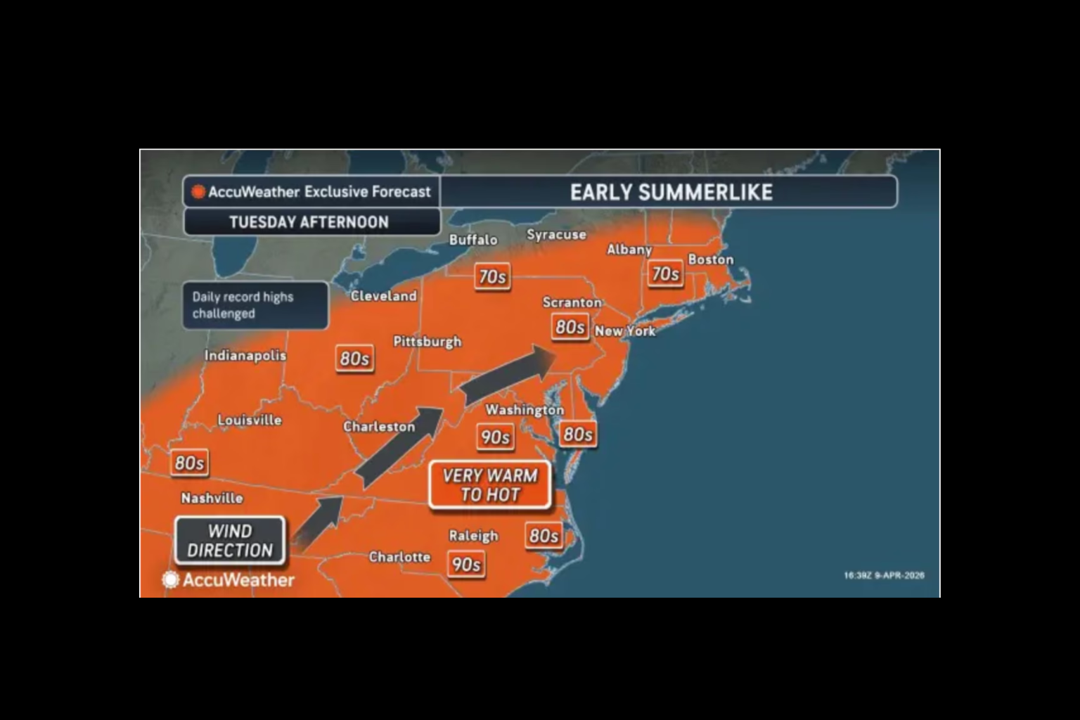
On Tuesday, warmer air will become more noticeable, pushing highs into the lower 80s. This will mark the beginning of a more pronounced warm spell spreading across the state.
By Wednesday, conditions are expected to peak with widespread highs in the 80s across much of New Jersey. Some of the typically warmer areas could approach 90°F. Overnight lows will also remain mild, staying mostly in the 60s, making for a warmer-than-average night.
Weather experts also note that a cold front may move through the region from Wednesday into Thursday. If it arrives as expected, it could bring an end to the warm spell and return temperatures closer to seasonal norms.
Overall, the pattern points to a clear transition from a calm, dry weekend into a significantly warmer and more summer-like stretch of weather by midweek, with residents advised to prepare for rising temperatures and changing conditions.
Sources:
National Weather Service
AccuWeather